


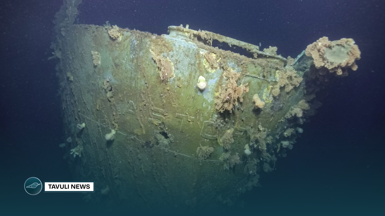
Nautilus expedition surveys WWII shipwrecks in Iron Bottom Sound using advanced ocean mapping and ROV technologies.

The Ocean Exploration Trust (OET)’s exploration vessel, E/V Nautilus, has launched its third expedition of 2025 to survey historically significant World War II shipwrecks in Iron Bottom Sound, Solomon Islands. The site was the location of five major naval battles during the Guadalcanal campaign in 1942, a pivotal point in the Pacific theater of WWII.
Led by OET President and ocean explorer Dr. Robert Ballard, the 21-day mission will use remotely operated vehicles (ROVs) in tandem with the University of New Hampshire’s uncrewed surface vessel (USV) DriX. The collaborative technology approach is supported by NOAA Ocean Exploration through the Ocean Exploration Cooperative Institute, aiming to improve archaeological mapping and documentation of the area.
“Iron Bottom Sound was where we discovered 12 lost ships in 1991 and 1992,” said Dr. Ballard. “This time, we’re using more advanced acoustical and imaging technologies to locate and document additional vessels and aircraft that remain undiscovered.”
Iron Bottom Sound, located off the coast of Honiara, saw intense naval conflict between August and December 1942. The battles resulted in the loss of over 20,000 lives, 111 ships, and 1,450 aircraft from Allied and Japanese forces. While 30 shipwrecks have been located, at least 21 remain uncharted in the deep waters of the area.
According to Captain William Mowitt, Acting Director of NOAA Ocean Exploration, combining deep-diving ROVs with USV DriX allows for more efficient and detailed exploration. “By integrating these tools, we can expand our understanding of both maritime history and the deep ocean.”
The team will use DriX to produce high-resolution seafloor maps and identify specific sites for ROV dives. Non-invasive surveys by ROVs Hercules and Atalanta will then assess the condition of the wrecks, their ecological value as artificial reefs, and any potential environmental risks from remaining materials.
Dr. Larry Mayer, Director of the Center for Coastal and Ocean Mapping at the University of New Hampshire, noted the emotional weight of the mission: “It’s both humbling and sobering to chart these sites, given the scale of loss and their historical significance.”
The mission brings together archaeologists and researchers from the United States, Japan, Australia, and New Zealand, along with global experts through the Scientist Ashore program. The goal is to promote international cooperation while preserving the memory of those who perished during the Guadalcanal campaign.
“These wrecks are the final resting place of sailors from all sides,” said Rear Admiral (Ret.) Samuel J. Cox, Director of the U.S. Naval History and Heritage Command. “This mission serves as a reminder of the cost of conflict and the importance of remembering those who never returned home.”
The Maritime Archaeology of Guadalcanal Expedition is supported by NOAA Ocean Exploration and multiple partners, including the Solomon Islands Government, University of New Hampshire, and heritage institutions from participating nations.
The expedition is being streamed live via NautilusLive.org, enabling public access to real-time ocean exploration. Through this telepresence platform, viewers can interact with scientists, ask questions, and follow the mission on social media. Free educational sessions are also available for classrooms worldwide.
Following this expedition, OET will continue its 2025 field season with missions in the Republic of the Marshall Islands and Wake Atoll. The expeditions contribute data to U.S. and international ocean mapping efforts, including the U.S. National Strategy for Ocean Mapping, Exploration, and Characterization and the Beyond the Blue: Illuminating the Pacific campaign.
SOURCE: NAUTILUS PRESS RELEASE